
Least Squares Coordinate Transformation Application
Least-Squares Two-Dimensional Conformal Coordinate Transformation Software
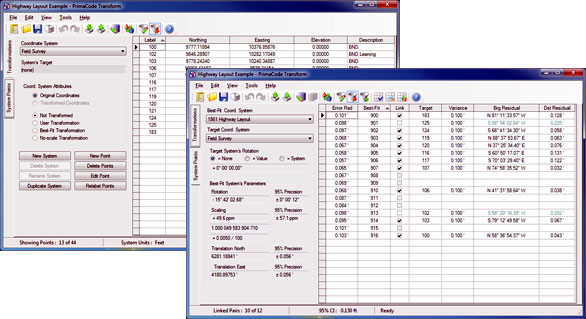
Of its many uses, Transform is most ideally suited for analyzing the evidence found on-the-ground marking a boundary survey or for analyzing the dimensions used to describe the boundary survey via statistically rigorous least squares coordinate transformation.
The comparison is as easy as setting or clearing a checkbox indicating whether a pairing of a boundary survey map point to a point found on-the-ground should be held or ignored while Transform transparently and instantaneously produces a new solution for the surveyor with each pairing that is linked or unlinked.
As a result of linking paired points, Transform transparently best-fits the points delineated on a boundary survey plat to the points found on-ground via a least squares coordinate transformation solution, reports the error of each found point, provides positional uncertainties, rotates either system's meridian to match the other's, provides transformed coordinates, provides statistically most-probable coordinates for points found unmarked and provides all the necessary statistical data need to evaluate/analyze both surveys.
Highlights
Best-Fit Coordinate Transformation
Transform is the easiest, fastest and most powerful way to best-fit one coordinate system to another. Due to its intuitive user interface and robust feature set, Transform sets the standard for all other least-squares two-dimensional conformal coordinate transformation software solutions.
Identifying Common Points
Transform provides several ways to help you find the points common to the two coordinate systems being compared, i.e. you can select common points by descriptions, by proximity estimates, by filtering, and by an automated statistical process that finds all matching pairs based upon a supplied variance.
Generating Solutions
New solutions are instantly generated each time the user pairs points common to the systems being compared, links or unlinks paired points or changes a point pair's variance . That's it! There is nothing more needed to set up or create a solution. Results are displayed instantly upon linking, pairing, or variance changes.
Survey/Deed Analysis
By comparing the solution's overall confidence value to the error of each paired point, the user can easily determine which points should be used to base a solution and which should not; in other words, when the outliers have been identified and eliminated.
Unifying the Coordinate Systems
Once the analysis is complete, i.e. selective linking and unlinking paired points, the best-fit transformation is complete, the meridian and coordinates of both systems have been unified, the unified coordinates are ready for viewing and export from Transform's point list view.
Unifying the Meridians
Once the analysis is complete, i.e. selective linking and unlinking paired points, Transform provides the difference in meridians and how precise that statistical value is. You now have a statistical based angle of rotation that can be applied to your fieldwork to match the meridian of the survey/deed being reproduced.
Units of Measure
Transform also provides a statistical comparison of the units of measure that forms the basis of each survey, therefore if one was measured with a steel-tape and the other ws measured with electronic equipment, then you will no by how much the two differed.
Accuracy & Reliability
The statistical precision of each solutions is also provided, so the user can readily asses the reliability of the solution and the error radii of each point in the transformed coordinate system.